


AllTrails Introduces “Peak” Membership With AI-Powered Trail Features
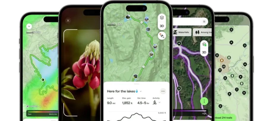
AllTrails, the popular outdoor navigation app and 2023’s iPhone App of the Year, is stepping up its game with a brand-new subscription tier called “Peak”, priced at $80 per year. This enhanced membership includes an array of intelligent tools, including AI-generated custom routes, real-time trail condition updates, and even a plant-identification camera feature—all aimed at making outdoor exploration smarter and more personalized.
Smarter Hiking With AI
The standout feature of the new Peak plan is its AI-powered route planning. Subscribers can now design their ideal hiking or biking path by either starting from scratch or modifying existing trails. The smart-routing system uses artificial intelligence to tailor routes that are shorter, less steep, or more scenic, depending on the user’s preferences.
Other premium tools include forecast data for trails, delivering critical information like temperature, precipitation, and snow depth. Alerts for air quality and mosquito activity are also part of the offering, with upcoming updates expected to include terrain details such as whether a trail is paved, gravel, or muddy.
Anticipating Trail Traffic
The new Peak membership also grants access to a trail traffic heatmap, built using anonymized activity data from millions of AllTrails users. Much like Google Maps’ popular times feature, this tool helps hikers and bikers decide when to hit the trail to avoid crowds—or, conversely, to be surrounded by others for added safety.
Outdoor Lens: Nature Identification On the Go
Another highlight of the Peak plan is the new Outdoor Lens, a camera-powered feature that lets users identify trees, flowers, and other plants instantly. Users can log these discoveries directly within the app. AllTrails noted that additional nature identification capabilities will be added over time, expanding the educational value of the platform.
Staggered Rollout With Global Access by June
While the Peak plan is not immediately available to everyone, select AllTrails users will get access in the coming weeks, with a global rollout expected by June. Interested users can now sign up for early access via the AllTrails website.
Competing With Tech Giants
AllTrails’ move to enhance its offerings comes amid growing competition from tech heavyweights. In a timely twist, Apple expanded its Apple Maps functionality just before honoring AllTrails as its App of the Year. The updates included topographic maps, trailhead markers, elevation contours, and national park coverage. The following year, Apple doubled down, adding offline maps, customizable routes, and features geared toward global trail exploration.
This increased competition appears to have prompted AllTrails to double down on innovation, especially for its most engaged users. The new Peak tier is clearly a strategic response to stay ahead in a growing market for outdoor tech tools.
Building on Pandemic-Era Growth
AllTrails saw significant expansion during the COVID-19 pandemic, a time when people sought outdoor spaces for safer recreation. In 2021, the company raised $150 million in a growth funding round, helping it to scale in response to this surge in demand.
Today, AllTrails boasts a community of over 80 million registered users, and the new Peak membership is expected to appeal to its most active adventurers.
Upgrades for Free and Plus Members Too
In addition to launching Peak, AllTrails is also upgrading its Base and Plus memberships.
-
Base: The free tier continues to offer essential features like trail maps, user reviews, and basic navigation tools.
-
Plus: This tier adds extras such as offline trail access, wrong-turn alerts, 3D previews, and real-time activity sharing.
Both tiers are receiving a new Points of Interest feature that maps over 500,000 landmarks, viewpoints, and trail amenities. Plus subscribers also gain access to Offline Area, allowing them to download custom regions with high-resolution maps for disconnected exploring.




0 Comments